Meet the 3J Geospatial Services Team

Over the years, 3J has thoughtfully expanded our services to enhance project delivery and create greater value for our clients. As our expertise grew, we recognized a natural connection between our aerial photography, GIS, and hydrologic and hydraulic modeling services.

3J’s Geospatial Services team brings these capabilities under one banner, reflecting the integrated approach we’ve long delivered to clients while providing a clearer representation of our capabilities.

A map that distills spatial analysis into something a city council can act on. A custom mobile app that turns weeks of ADA inspections into days. Aerial imagery that catches a design issue before it becomes a construction problem. Hydraulic models that give engineers a clearer, more accurate picture of how water moves through a landscape.

That work has always been here, and now we’re giving it space to shine.

We sat down with a few members of our Geospatial Services team to hear what they had to say about the work they love and why geospatial thinking makes every project better.

Geospatial Services

Julia Reisemann
Senior GIS Manager
For our engineers, some of the typical requests are converting data from or to CAD, or a map. For our folks out in the field, we create apps to simplify the task of data collection. For example, we developed an app for ADA ramp inspection. The app includes multiple components but what makes it cool and pleasant to use is that it looks very similar to ODOT’s ADA ramp inspection form. We also work closely with our water resources folks and help them either with reports or prepare data to be used for HEC-RAS modeling.

For planning, we usually are involved for the entire length of a project. Here, we can use our cartographic side by creating beautiful maps that communicate the matter at hand. But what most people don’t realize, a simple map might have weeks if not months of analytics behind it. This can include collecting data sets from various sources, ground proofing, review, and running analyses by combining multiple data sets, to final review.

When a planner or engineer brings you into a project, what does that typically look like?
The City of North Plains ADA ramp inspection app cataloged over 400 ramps using a custom mobile application you helped develop. What made it work, and what did the city gain from it?
It all started with “we can make an app for that!” The City asked 3J Consulting to inspect its ramp for ADA compliance. A large amount of data needed to be collected for this purpose.

Instead of using an out-of-box app that would have been 50 or more lines of questions after question, we developed our own app that uses the jurisdiction's inspection forms within its layout. Using a tablet and having all necessary steps centralized with an app made it easier on our inspectors. No having to handle multiple media, such as the different paper forms, a street map, or a camera.

The app itself includes a map to identify the location of a ramp. With the location selected, the inspector then picks one of multiple forms that fit the type of ramp. The information is entered, and photos are taken. Using the app sped up the process by multiple weeks, saving the City money.
What's something clients don't know to ask for from a GIS team, but almost always wish they'd had earlier in a project?
That’s a great question. Too often, GIS is restricted to very little contact with the client. The client might be only aware that there is a GIS because of a data request they receive.

Here at 3J Consulting, we handle the involvement of our Geospatial group differently.

Depending on the role we will have, we participate in meetings, discuss the needs of the individual project and share results with the client. Having familiarity and communication with the clients breaks down barriers to communication and allows us to work together more seamlessly and understand the project more thoroughly.
Phillip Patague, PE, CFM
Senior Water Resources Engineer

You use GIS as a core part of hydraulic and hydrologic modeling. How does that integration actually improve the work compared to more traditional approaches?
GIS increases my efficiency in my analyses without sacrificing accuracy. Without GIS, I would have to make assumptions about the hydrologic properties of large swaths of areas. As your study area increases in size, the accuracy of your model decreases because the spatially averaged values now represent too much area. You can break up your study area and evaluate hydrologic parameters for those smaller areas, but then your workload will increase. GIS allows you to be more granular in your analysis, theoretically increasing the model’s accuracy, while maintaining efficiency.

Regarding hydraulic modeling, GIS allows me to visualize hydraulic results effectively and efficiently for our clients. A more traditional approach would require our clients to cross-reference my report narrative with multiple exhibits to understand the results.
I use a combination of tables, exhibits, and report narrative to explain input parameters, assumptions, and results. I use tables in my report narratives to display critical (maxima or minima) values that might help the reader quickly assess risk.

GIS is perfect for conveying hydraulic modeling results, like depth, velocity, and scour. This helps planners and project managers determine which materials and structural measures are needed. I think it’s also important and valuable to provide spatial results in other formats, like KMZ (Google Maps), to accommodate clients.
Water resources work involves a lot of complex data. How do you make sure those findings actually land with the people who need to act on them?

What's a project from the past couple of years that you're most proud of, and why?
I am very proud of my growth in two-dimensional hydrologic and hydraulic analysis. When I show other Engineers in the office what I do, a common response I hear is “This is what I thought I’d be doing as an Engineer.” I like that Water Resources involves research into understanding input parameters, assumptions, and limitations of the results. On a basic level, I love that I get to create some colorful maps and animations. I like that this kind of work is allowing me to work on projects around the country.
Collaborating with the GIS department has been great because they spot inefficiencies in my GIS workflows and work with me to come up with more economical solutions. I don’t have coding experience, and GIS having that knowledge helps us come up with novel and inventive solutions.

The Planning department solves broader problems, which is a departure from engineering solutions that get into much finer detail. We help them by identifying anticipatory water resource issues. I like this because it requires us to do our due diligence to mitigate undesired results in the future.

Water Resources works toward analytical accuracy. Planning works toward narrative and rationale accuracy. GIS works towards visualization accuracy. We need each other to solve complex problems.

How does having water resources, GIS, and planning all in-house at 3J change what's possible on a project?
Taryn Girard, PE, LSI
Civil Engineer
I've found simply being able to view a project from the sky can really benefit your whole perspective on the site, from being able to see how close a new school will be to a busy highway or how a road widening will affect the frontage of several homes.

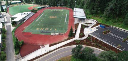
I remember flying some sidewalk/half street improvement projects in Washington County, and on multiple occasions we found that based on the aerials we collected, we made sure to modify our driveway placements to better reflect how the adjacent homeowners actually utilized their driveway entrances, which hadn’t been clear just based on the topographic land survey.
What's something you've been able to document or capture from the air that genuinely surprised you or changed how a project team was thinking about a site?
When does aerial data genuinely save a client time or money — what's a scenario where you've seen that play out?
Aerial data can operate as a cost-saving option in the way that it provides our clients and us with a time-saving tool. When the City of North Plains wanted to visually assess the pavement conditions across the City to aid in their Capital Improvement Project (CIP) decisions, flying the miles of roads and assessing the status of their public streets via desktop saved possibly days of manual in-field inspection.
I've been serving on the ASPRS Board for a little over a year now and have transitioned into the President role recently. ASPRS is the American Society for Photogrammetry and Remote Sensing. I was drawn to the ASPRS community by some mentors of mine, and I have found it to be an incredible organization to be a part of to be able to connect with others in the industry who are utilizing geospatial data with technology at my level of understanding and others who are us tech far beyond my expertise.
You were recently elected Vice President of the ASPRS Cascadia Region. What is ASPRS, and what drew you to that role?
What kind of client or project gets you the most excited to come to work?
I am super excited about our clean energy portfolio and the great clients we’ve gotten a chance to work with in that industry. The sheer scale of these projects really complements our geospatial knowledge and abilities, while remaining complex but very rewarding projects.