Geospatial Services
Our Geospatial Services
Our GIS Team
Our GIS team works alongside our planners, engineers, and public involvement specialists to deliver maps, analyses, and applications that support sound decision-making from early visioning through project implementation.
Asset Management
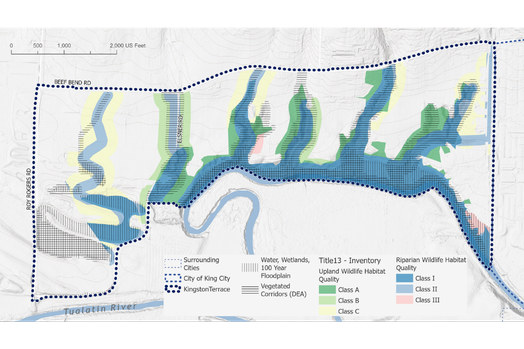
Buildable Land Inventories
Hydrology Studies
Map Making
Mobile Data Collection
Scenario Planning
Spatial Analysis
Stormwater Management
UGB Analysis
Web Applications
1D & 2D Hydraulic Modeling
Aerial Photography
Mapping & Analysis
3J produces professional-grade maps and spatial analysis for planning documents, public outreach, technical reports, and agency submittals. We work at any scale and integrate local, regional, and national datasets to produce findings that hold up to technical scrutiny and communicate clearly to any audience.
Spatial analysis
We analyze geographic data to answer complex planning and engineering questions: Where are the buildable lands? Which areas face flood risk? How has growth changed over time? Our analysis integrates local, regional, and national datasets to produce findings that are both technically sound and locally meaningful.
Buildable Land Inventories
Our BLIs are prepared in compliance with Oregon state regulations. We apply zoning codes, environmental constraints, and ownership data to identify lands available for development, with jurisdiction-specific findings that support housing capacity analysis and UGB planning.
UGB Analysis
3J supports communities through the urban growth boundary process with scenario modeling, land supply analysis, and map preparation for comprehensive plan updates and submissions.
Data Collection & Management
Good analysis depends on good data. 3J builds and manages the systems that keep infrastructure information current and useful, whether that means developing a purpose-built mobile app for field inspections or maintaining a centralized asset database that informs capital planning decisions.
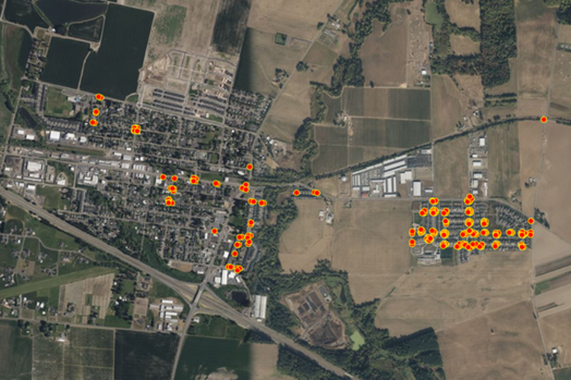
Mobile data collection
3J develops custom mobile applications so field staff can capture measurements, photos, and location data in real time. For the City of North Plains, our ADA ramp inspection app cataloged over 400 ramps, auto-generated compliance forms, and enabled real-time GIS monitoring throughout the project.
Asset management
We build GIS-based systems that give agencies a clear, up-to-date picture of their physical infrastructure. Stormwater networks, roadway condition, parks facilities, and ADA compliance data are centralized in a single platform that supports ongoing maintenance prioritization and long-term capital planning.
Infrastructure assessment
3J combines GIS analysis with public input and field data to assess infrastructure condition and equity across a community. Our work in McMinnville used an online web map to collect resident feedback alongside spatial analysis of roads, sidewalks, parks, and utilities, producing a findings memo that will guide equitable investment decisions for years to come.
Site monitoring & inspection
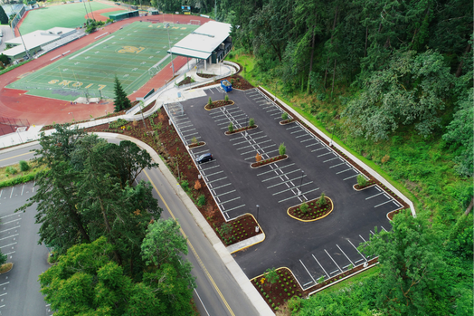
Overhead imagery gives project teams a vantage point that ground-level photography cannot provide. We use UAV flights for construction progress monitoring, infrastructure inspection, and asset documentation, building a visual record that can be compared against design plans at any stage.
Pavement & asset data collection
Aerial imagery supports pavement management and asset condition work, giving agencies spatial context before committing to inspection routes or rehabilitation priorities. UAV data integrates directly into our GIS workflows for analysis and reporting.
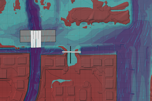
Hydrologic and Hydraulic Analysis
3J applies GIS to hydrologic and hydraulic analysis work, connecting spatial data to stormwater planning, floodplain management, and watershed studies. This integration strengthens the technical foundation of projects and helps agencies communicate findings to non-technical audiences.
Hydrology studies & stormwater management
We delineate watersheds, map drainage infrastructure, and identify system deficiencies to support stormwater system design, capital improvement programs, and environmental permitting.
1D & 2D hydraulic modeling
Our team performs one- and two-dimensional hydraulic modeling to evaluate water surface profiles, floodplain extents, and channel conditions. GIS is central to model preparation and results visualization, making it easier to communicate flood risk findings to engineers, planners, and the public.

